.jpg)
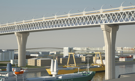
Petrovsky Bridge with its complex cable stays
The city of St Petersburg is already famous for its many bridges which span the River Neva and other waterways, forming part of the culture and heritage of Russia’s second city. Now new bridges are beginning to appear to the west of the city as part of a vital new transport link.
Like many other cities, St Petersburg suffers from traffic congestion and the consequent reduction in air quality. City planners worked hard to address this problem during the last few decades of the twentieth century and an orbital motorway was built, incorporating a flood defence barrier at Kotlin Island, across the Gulf of Finland to protect the low-lying city. But with the western loop of the motorway some 60km from the city centre, it is not often used for local journeys.
The last link in the network, which is currently being built, is a north-south diameter route. This section is now moving into its final, and most challenging, phase with construction under way of a dual four-lane road skirting St Petersburg’s western shoreline, crossing all water access points to the city as well as the busy port district.
.jpg)
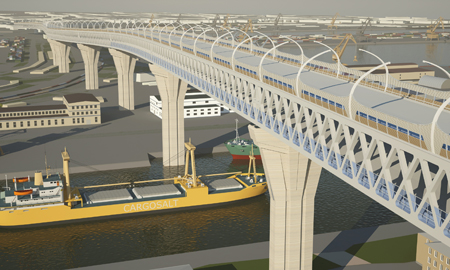
Korabelny Fairway bridge has inwardly-inclined towers
Less than 12km in length, but costing US$1.6 billion and with a three-year construction programme, it includes three major high-level bridges, together with low level viaducts and smaller overbridges (see box). As part of its planning for the diameter concept, St Petersburg City Council established an arm’s length company, Western High Speed Diameter, to oversee the preparatory work. As the only realistic funding model was a public private partnership, ‘special purpose vehicle company’ Northern Capital Highway was also created with sole responsibility for the execution of the scheme.
As NCH chief executive, Alexey Bnatov explains, “The city council required a company to finance, build and operate the full length of the diameter and to recover the investment through tolls over a fixed 30-year concession period. NCH will undertake all aspects of those functions for the next 30 years before the road is returned to the city.” NCH already operates and collects tolls on the orbital’s initial phases in the north and south of the city, completed in 2008 and 2012 respectively, but the full impact will only be realised when the link is finished. As traffic volumes increase, NCH has a contractual requirement to ensure that queues for toll plazas do not exceed lengths specified by the council. It is also committed to increasing electronic tolling via in-vehicle transponders and hopes that a 20% toll discount against cash payments will increase the take-up.
The genesis of the project stems from the early 1990s when St Petersburg City Council was preparing a bid for the 2008 Olympic Games and recognised the need for transport improvements as part of the proposal. A feasibility study was completed in 2001 and an alignment corridor established. Although the Olympic bid was not successful, the concept of a diameter link had been established.
In 2003, the city celebrated the 300th anniversary of its founding by Peter the Great and both the city council and the Russian Federal Government authorised design to start. Scheme design was awarded to consultant Stroy Proekt and WHSD appointed Professor Semeon Suponitsky as technical director to guide and oversee the work. As Suponitsky explains, “This project has benefitted from the continuous involvement of personnel on all sides, myself at WHSD and Tatiana Kuznetsova and Alexey Surovtsev at Stroy Proekt”. The southern part of the diameter was more than just the first link from the orbital motorway: part of the project saw the completion of a new 40Ha grade-separated junction easing connectivity between St Petersburg and the strategic routes to Moscow, Kiev and Tallinn.
The new highway, already carrying up to 80,000 vehicles per day, also provided a direct route to the new container port, greatly adding to the city’s prosperity, and at the same time diverting heavy vehicles from residential streets. Nearing the sea, however, the road corridor narrowed through the approaches to the port district, an area congested with major gas and water pipelines as well as the historic Kirov Tractor/Tank factory and other military sites.
Although the new road will be carried on viaducts, the dual four-lane still has to pass through a gap of half its width, a problem which led to the choice of a double-deck structure as a solution. A few hundred metres of the link was built as part of this phase but at a low level to suit the traffic interchange which allows access to the southern section from the port.
The Sea Channel Bridge carries traffic in a double-deck arrangement
Extending this bridge is the start of the present works, now under construction as part of the diameter’s last phase. The superstructure of this double-deck structure, known as the Sea Channel Bridge, is to be a 6m-deep truss with spans of up to 168m, rising on a steep gradient to cross Kanonersky Island and the main channel to the port at a maximum clearance of 52m before descending over Gutuevsky Island.
Although on a straight horizontal alignment for most of its length, the bridge curves northwards to skirt the western shore of Bely Island where the transition from a double deck back to a conventional side-by-side arrangement takes place back. The navigation clearance of the Sea Channel Bridge was the subject of much debate during the planning phases: the first feasibility study proposed a clearance of 70m to match that of the Øresund Bridge, but this was later dropped to 52m to reduce the length of the approaches required. The bridge will be launched into position in a complex operation.
Although the transition from double deck to conventional alignment marks the end of the Sea Channel truss bridge, the road is then carried on a low level viaduct before it begins its climb to the next major structure. This is the 320m-long main span, Korabelny Fairway cable-stayed bridge, with its inwardly-inclined towers which will give it a striking but unusual elevation.
Stroy Proekt designer Tatiana Kuznetsova explains: “The island of Vasilievsky in the west of St Petersburg is connected to the rest of the city by four bascule bridges. Each night at 1.30am the bridges are opened and the leaf bascules are left at an angle of 12.5° until the morning. This is the incline of the towers we have chosen for the Korabelny Bridge.”
.jpg)
SP’s Alexey Surovtsev accepts that this is an unconventional arrangement: “Although the inward incline may appear structurally inefficient and counter-intuitive, it will add to the landmark status we want the bridge to have. We have also thought through a detailed methodology for rapid construction which will allow tower, cable and deck erection to be undertaken at the same time.”
.jpg)
Heading north from Korabelny, the road continues on another viaduct until reaching the reclaimed land at the west of Vasilievsky Island where, for environmental reasons it drops below ground and sea level in an open cutting, crossed by a number of minor road bridges and an aqueduct carrying the Smolenka River. The area of reclaimed land, made from dredged material, is already the site of a new cruise liner port, with facilities for up to seven liners at any one time. Rising again as it leaves Vasilievsky Island, the road crosses the Petrovsky Channel on its third major bridge; another cable-stayed structure.
.jpg)
Although with a relatively modest 240m-long main span, this will be another visually impressive structure. Symmetrical about two needle-shaped towers, the deck will be supported on four planes of cables; the cables supporting the deck units closest to the tower will be connected to the top of the tower, with those towards mid span connected at a lower level. Renderings of the bridge show how the cables will form intricate web-like patterns that will be experienced by drivers and sailors alike.
.jpg)
NCH project director Alan Platt accepts that the geometry is complex: “There may be problems with cables crossing in the same plane which will have to be addressed but Petrovsky adds another aesthetic landmark to this length of road.”
In fact, the Petrovsky cable-stayed proposal is a relatively recent change: it had originally been conceived as an extradosed bridge with massive concrete towers. The change followed concerns about achieving a tight programme and tackling issues associated with complex casting sequences and high-strength concreting in Russian winters.
Finally, the road crosses the mouths of the Big and Middle Neva Rivers on another low-level viaduct before landfall where it connects to the already-built northern section of the WHSD at Primorsky Prospekt interchange.
Although by definition a road is a linear project, construction activity has been split into five sections and is progressing simultaneously on all structures. St Petersburg was originally built on marsh land and ground conditions are mainly weak alluvial material; all new bridges, therefore, are founded on large diameter bored piles, to depths of up to 40m.
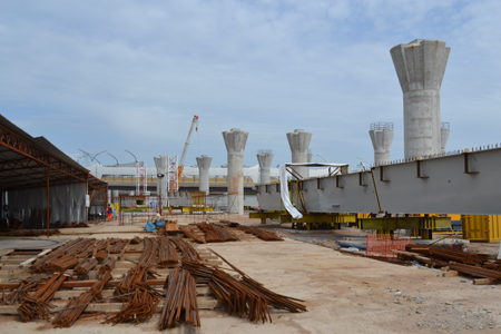
Piling started soon after work began in April 2013 and the last pile was installed in June this year. Access to foundations in waterways has been achieved by constructing ‘islands’ of fill material connected by substantial temporary bridges. This offers almost unrestricted movement between piers and eliminates the risk of restricted access when the river and sea freeze.
Platt recalls the urgency of getting all the islands in place before the winter of 2013 which ironically turned out to be the warmest for 30 years; all activities, including concreting, were able to continue throughout. He recognises, however, the wider benefits for the project derived from this significant investment in temporary works. Piles are cased and were bored through the islands before steel sheet pile cofferdams were formed to enable excavation to below sea or river bed levels. Conventional pile caps and concrete columns then support superstructures: mostly steel box composites for the viaducts, currently being fabricated at five sites across Russia and being stored on site in readiness for erection.
With a 36-month programme to complete and open the road to traffic, already scheduled for April 2016, there is a great deal of activity on all stages of the project with some 3,000 people employed either by main contractor ICA or its 70 subcontractors. Helped by good planning and the substantial commitment to temporary works to secure access, works in June 2014 were generally on programme although some service diversions in the congested industrial areas at the south end of the site were starting to slip. Platt says: “Like almost any project in the world, we are in the hands of third party utility companies when it comes to moving their plant and apparatus”. In response to a question about what is on the critical path, he answers: “Everything!”
Contractor’s representative, Mete Demir, agrees that the service diversions are frustrating but also cites how essential it was plan ahead to gain consents and approvals for all activities – from port authority regulations to environmental issues such as pollution control and water quality at times of fish spawning. “It is essential to understand the requirements of all statutory bodies well in advance and to build them into the programme. We cannot afford any last-minute surprises.”
Apart from the drive over the high level Sea Channel bridge, affording spectacular views of city and sea, and over two unusual cable-stayed bridges, users of the diameter route will also be aware of the architectural features of the road.
Curved steel street light columns from both central median and verges sweep over the carriageway, giving the impression of driving through an enormous rib cage. Where required, additional environmental barriers are affixed between lamp columns with a similar curvature, in places almost enclosing the road. Toll plazas have also been given the same architectural treatment, one of which will include a traffic control tower which reflects the same design as that used on bridge piers throughout the whole diameter.
As Bnatov says, “We want the users of this road to realise they are driving on a different type of highway; it’s the first urban toll road in Russia and the aesthetics help to distinguish between the High Speed Diameter and the rest of the city network.” There is little doubt that this will be a spectacular length of road which will provide a fast and popular alternative when crossing the city. With three new landmark bridges within sight of each other, St Petersburg will perhaps even emulate other cities such as New York and Hong Kong where major bridges and waterways combine to define city-scapes. Although all parties are aware that there is much complex and challenging bridge engineering to be completed against a tight programme before the diameter becomes a reality, the planning, preparation and quality of the team charged with delivery should ensure success.
Main parties
Client: St Petersburg City Council and Western High Speed Diameter Company
Special purpose vehicle: Northern Capital Highway
Designer: Stroy Proekt
Contractor: ICA Astaldi/IC Ictas Insaat Anonim Sirketi /Mega Yapi JV
Construction control: Cowi
Consortium partners: Gazprombank, VTB Capital
Lenders: Eurasian Development Bank, European Bank for Reconstruction & Development
Bridges on the project
Sea Channel Bridge (Brown truss, spans 120m to 160m)
Kanonersky Island to Korabelny Fairway Twin (steel box composite viaduct, spans 84m to 126m)
Korabelny Fairway (cable-stayed bridge, spans 150m – 320m – 150m)
Korabelny Fairway to Vasilievsky Island (twin steel box composite viaduct, spans 48m to 126m)
Cutting in Vasilievsky Island (five overbridges and aqueduct carrying Smolenka River)
Vasilievsky Island to Petrovsky bridge (twin steel box composite viaduct, spans 48m to 78m)
Petrovsky Bridge (cable-stayed bridge, spans 110m – 240m – 110m)
Viaduct over Neva Rivers (twin steel box composite viaduct, spans 84m to 126m)