Changes to the rules relating to the use of unmanned aerial vehicles in the USA have just come into effect this month (August) – at a crucial time for the many US state Departments of Transport following Minnesota DOT’s pioneering bridge inspection research work.
At this year’s International Bridge Conference in Maryland, USA, Bd&e caught up with MNDOT state bridge inspection engineer Jennifer Zinc and Collins Engineers regional manager Barritt Lovelace. They were presenting details of a project that will lead to the USA’s first state-wide contract for unmanned aerial vehicles in 2017.
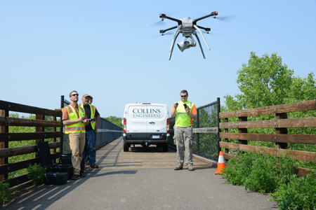
The project started in April 2015 with the intention of evaluating the safety and effectiveness of UAVs as a potential alternative to aerial work platforms or rope access for inspections. By definition, these traditional access methods involve a large amount of traffic coordination and an element of risk for operators and inspectors. In addition, MnDOT wanted to ascertain whether use of UAVs could address the increasing costs of bridge inspections.
Originally expected to be a relatively minor two-month project, the research effort has expanded into three phases and currently the DOT is in the later stages of phase two, with phase three due to follow next year.
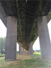
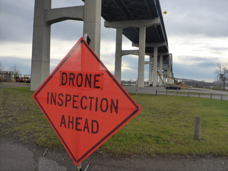
In phase one, four bridges in Minnesota were selected based on local agency cooperation, safety, type and size of bridge, location and FAA requirements. These were a prestressed beam bridge in Chisago County, a concrete arch in Oronoco, a pedestrian steel deck truss in Little Falls, and the Arcola Bridge, a high steel arch railway bridge in Stillwater. For each bridge a detailed fieldwork plan was prepared addressing safety, FAA rules, and inspection methods.
The main challenges of this first stage – which involved carrying out an inspection with a UAV capturing still image, video and infrared images – turned out to be bureaucratic rather than operational.
At the time the project started, FAA regulations stipulated a number of requirements for the use of UAVs for commercial uses such as bridge inspections. So onerous were these demands that it had become widely accepted in the US that the time and costs of complying with them ruled out such technology for bridge inspections.
The FAA’s core rules required that a UAV must be certified and registered; operated by a licensed aircraft pilot and within line of sight; and not operated within 8km of an airport without permission.
In addition, commercial operators had to obtain the Section 333 Exemption & Certificate of Authorisation, a document which was provided on a case-by-case basis and which could take up to nine months to secure. Even when the FAA granted this to the MnDOT research team, it carried the additional restriction that the UAV must maintain a minimum distance of 152m from non-participants.
However, the strict limitations of the FAA’s rules and the team’s extensive pre-field planning delivered some useful – if unexpected – lessons. At the start of phase one the team had only been granted an exemption for one UAV even though applications had been made for several different models. This underlined some significant, practical features and capabilities that should be specified for UAVs destined to be used for bridge inspections.
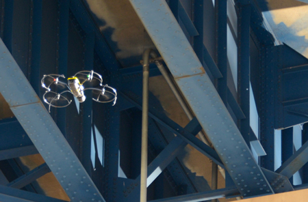
The US$140,000 Aeyron Skyranger model for which the team had secured the exemption had the ability to carry standard, optical-zoom and infra-red cameras and carried a 50-minute battery life – extremely long by industry standards.
However, it did not carry a camera that could point upwards, something that the team was aware of. A work-around in the form of a 360° video camera that was mounted on top had been installed but, unfortunately, it did not perform correctly due to wi-fi signal interference.
The second lesson learned was that an inspection UAV must have the ability to fly even without a GPS, as Lovelace explains: “Most drones are programmed so that if they lose their GPS signal they fly to a certain height, move to where they took off from and land on their own. This is a great feature except during bridge inspections, where if you are under a deck and lose your signal, you lose your drone.”
In spite of the inability to manoeuvre under bridge decks, the positive field observations relating to the safety and effectiveness of UAV technology outweighed the shortcomings and, consequently in summer 2015, funds were released for a second phase.
The aims of this phase, which is ongoing, include producing a cost comparison between the use of unmanned aerial vehicles and aerial work platforms; conducting further research into different UAV technologies such as infra-red cameras; developing a best-practice document; and devising parameters that define the types of bridges suitable for drone inspections within MnDOT’s inventory.
For phase two a Swiss-made inspection UAV was acquired, the Sensfly Exom (now renamed Albris), which can capture high-resolution still, thermal and video imagery ahead, above and below. It also carries five ultrasonic proximity sensors enabling an operator to manoeuvre the vehicle close to structures. “This drone has LED lighting so in a dark space it will provide illumination. It has two monitors set up, one for the pilot to operate the drone and one for the inspector to see what it is doing in real time. While the operator was piloting the drone, I was controlling the cameras and I could talk to him and say where to go,” remarks Zinc. And crucially, its GPS mode can be switched off.
As part of the testing Zinc and Lovelace compared the UAV’s infra-red images with land-captured infra-red images as well as chain drag data: “Our conclusion was that the drone infra-red images were as good as those taken using hand-held cameras. The advantage is that the drone camera can potentially be used without closing traffic and the images can be stitched together to create a map of the results,” says Lovelace.
While publication of the full results of the second part of the research, which includes the cost comparison as well as inspection-specific drone technology and best-practice guidance, has been delayed and is now not expected until later this year, Zinc is able to reveal some of the cost-related conclusions.
For the 2.4km-long John A Blatnik Bridge that carries the I-535 over the Saint Louis Bay between Duluth, Minnesota and Superior, Wisconsin, the cost and time savings would be substantial. Based on an initial cost comparison of UAV inspection versus traditional aerial platform inspection, Zinc’s team came up with cost savings of more than 60% and a reduced inspection time which could save between five and eight days. “Similar cost savings could be seen on other bridges,” adds Lovelace.
Once phase two of the project is complete, phase three will then begin. “For this we are going to implement a state-wide contract based on our bridges that are suitable for drone inspection. We will identify these through a structural management information programme based on the parameters we set for drone inspection, including state trunk and local bridges,” explains Zinc.

The contract will be used to obtain close-up inspection data for all bridges meeting the criteria of a new policy that covers state-owned and locally owned bridges. Traditionally, MnDOT handles fracture-critical and special bridge inspections while each district and county conducts routine bridge inspections using their own inspectors or consultants. The new policy is expected to outline that bridges rated in poor condition will require close-up inspection on a five-yearly frequency: “Access requirements to meet this policy could potentially be very costly, especially for local agencies. We anticipate that inspection by UAV can alleviate a lot of these costs,” says Zinc, adding that at the conclusion of phase two details regarding funding and state aid involvement will also be addressed.
It is not anticipated that the use of UAVs will impact adversely on bridge inspectors’ jobs, says Lovelace, because the National Bridge Inspection Standard requires that a certified inspector must be present to lead an inspection in order to ensure the safety of the travelling public. Simply reviewing post-inspection footage does not meet this requirement. “One of the interesting things is that there are many drone companies who say that they will do the inspection for you. What they are really saying is that they will go out there and take an hour of video of a bridge and give you that video. To a bridge inspector that is not very valuable. Three thousand images or hours of video would be too much. So we are trying to approach it as bridge inspectors, and just taking pictures of what we need to do a report.
“We have no doubt that we may go up and see something that we are not comfortable with, in which case we may need an aerial work platform to look at it. But that is still more efficient than doing the entire inspection with a platform if you don’t need to.”
Minnesota’s lead on drone inspections comes at the right time in the US, where the cost of such inspections is expected to go down in the next few years as a result of a recent announcement by the FAA. In June the FAA said that commercial operators would no longer need a pilot’s licence to fly UAVs weighing less than 25kg nor would they require a Section 333 Exemption.
From this month (August) commercial UAVs can be flown as long as the pilot is over the age of 16 and has passed an aeronautics safety test; has the UAV in his line of sight; and does not go more than 122m above ground level. Twilight flying is also allowed as long as the vehicle has lights that can be seen 5km away. “The new rules should speed the adoption of the technology and allow engineers to adopt it without as many hurdles as we faced,” says Lovelace, who adds that Collins Engineers is in the process of training bridge inspectors to use UAVs without the need for a separate pilot.