Despite being one of the longest rivers in South America, the Orinoco River in Venezuela has only two bridges on its entire 2,560km length. Both these bridges – the Angostura Bridge in Ciudad Bolivar and the Orinoquia Bridge in Ciudad Guayana – are on the lower part of the river, the closest to the Atlantic Ocean being 300km upstream of the delta.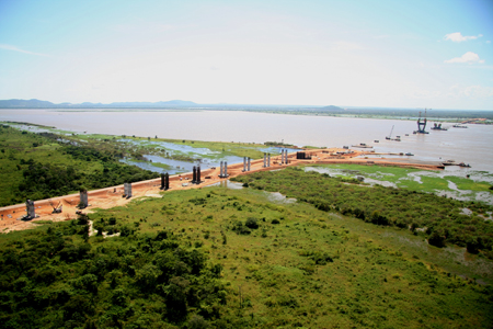
A new cable-stayed bridge which is currently under construction will provide a third crossing of the river, close to the centre of the country.
Of the existing bridges, the Orinoquia Bridge is about 300km inland from the river delta at Ciudad Guayana, the main centre for processing iron and bauxite ready for conversion into steel and aluminium. All of the heavy industries of Corporacion Venezolana de Guayana are based in this city. The structure is a cable-stayed bridge with two main spans of 300m and it was opened to traffic in 2006.
Some 100km upstream is the Angostura Bridge at Ciudad Bolivar, which is the capital of Bolivar state. This suspension bridge has a main span of 712m and was built in 1967.
The new bridge is located a further 400km upstream, close to a small town called Caicara del Orinoco on the south bank of the Orinoco River. This location currently has a ferry crossing for vehicles travelling from the northern part of the country, where its capital city is based, to the Guayana region. The new fixed link, which goes by the official name of the Dual-Purpose Third Orinoco River Bridge, will connect Bolivar State on the south bank of the river with Guarico State on the north.
It is also designed to accommodate rail traffic, should a future plan to build a railway between Caracas and the northern part of Bolivar State come to fruition. It was during the construction of the most recent bridge crossing that the idea of a third crossing was mooted, due to the economic importance of the state and the future development plans for the region.
Consultant Lustgarten y Asociados was involved in choosing the route and the conceptual engineering for the bridge for Brazilian contractor Construtora Norberto Odebrecht. The project was awarded to CNO, based on Lustgarten’s preliminary design, and the detailed design of the permanent works is being carried out by Consorcio Brave, which is a joint venture of Lustgarten and Figuereido Ferraz. Consultant Leonhardt, Andra & Partner was also involved in the concept and basic design of the temporary and permanent works, is independent checking engineer for the permanent works detailed design, and is responsible for the erection engineering and site assistance.
The new bridge also involves the construction of approximately 11km of elevated structures and new roads which are needed to link it to the existing highway system.
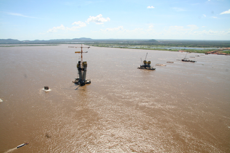
At the bridge site the river is 2.8km wide and has flow rates ranging from 66m³/s to 85m³/s. There is a single navigation channel which defines the location of the main span of the bridge and this is the point at which the river bed channel is located. This part of the river is mainly used by barge convoys which transport bauxite, one of the main components of aluminium, from mines upstream to the processing factories at Ciudad Guayana. The foundation pile caps are designed to resist the ship impact.
The river water level varies hugely over the year, with a difference of 12.5m between the highest and the lowest levels. This annual variation means that the floodplain of the river is very wide, which was the main factor driving the design of an 11km-long bridge as the final solution. Another important consideration in the design and construction of the new bridge is the fast-flowing current which can be up to 2m/s. For the design of the foundations it was necessary to take into consideration local scouring of up to 10.5m in addition to the global scouring.
Due to the extensive flood plain, the bridge structure has been divided into several different sections, each with specific characteristics. The bridge is divided longitudinally into four different sections each with different characteristics.
North and south A2 approaches consist of simply-supported prestressed concrete box girders with 35m long spans on concrete piers; the southern approach is 3.8km long and the northern one is 3.1km. They are located at each end of the bridge, next to the abutments and cross the flood plain of the river, carrying only highway traffic.
The adjoining sections of bridge at each side – known as the A2M approaches – are each 940m long and they have a superstructure of 60m-span continuous steel girders with a concrete deck working as a composite section and supported on concrete piers. The A2M approaches also carry only highway traffic. However the last four spans joining the A2M approaches to the A1 main bridge approach viaducts are designed to accommodate an additional steel superstructure in future. This will enable the railway traffic to be brought on to the main bridge structure via the A1approaches from an independent structure.
The superstructure of the A1 main bridge approach viaducts is continuous double deck steel trusses which have an upper and lower concrete deck working as a composite section with 120m-long spans between concrete piers. These approaches on the north and south are both 720m long, 19.2m wide and have expansion joints between the 360m-long structural sections. They link the A2M approaches and the main bridge, crossing over the main water course of the Orinoco River. They are intended to carry highway traffic on the upper deck and railway traffic on the lower deck; both decks are concrete.
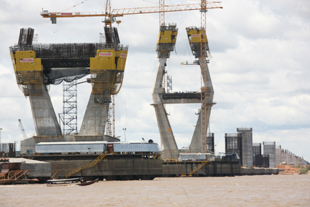
The main bridge over the navigation channel is an 840m-long cable-stayed bridge which has a central span of 360m and a total width of 21m. The double deck steel superstructure carries two highway lanes in each direction on the upper deck and a single railroad track on the lower deck. At each end, there is an access platform for maintenance purposes. It has two 120m spans at each end, and a 360m main span; the vertical clearance in the navigation channels above high water level is 41m, the same as the other two Orinoco River bridges.
Soil conditions on the main watercourse, which extends below the A1 approaches and the main bridge, consist of a thick layer of clay and sand sediment over very deep bedrock. The piers are founded on 2m-diameter concrete piles which are clustered in groups of 18, 22, 26 or 28, and spaced 5m apart in the transverse direction and 6.5m in the longitudinal direction. The main towers are founded on 39, 2.5m-diameter concrete piles, spaced either 8.1m or 5.6m apart in the transverse direction and 6.5m in the longitudinal direction.
The 2m diameter piles vary in length from 71m to 90m and the 2.5m diameter piles are each 90m long. They consist of driven steel tubes which contain cast in place concrete, using the steel tubes as forms within which the tremie concrete is poured. The pile cap for the piers is 5m deep while that for the main towers is 7m deep. The mean river level is +28m so the top level of the pile caps for a typical pier is placed at elevation + 33m.
As a result, they do disappear completely under water during part of the year due to the variation of the river level. However the tower pile cap, the t