Visitors to the Capilano Suspension Bridge in North Vancouver generally need to have a good head for heights – the famous pedestrian bridge is 136m long and crosses the Capilano River at a height of 70m, which means it is not for the faint-hearted. But the park now has a new attraction that enables visitors to see the gorge from even more dizzying heights – in fact they can get the same view as that seen by abseilers on the cliffs, but without the need to don a helmet and ropes.
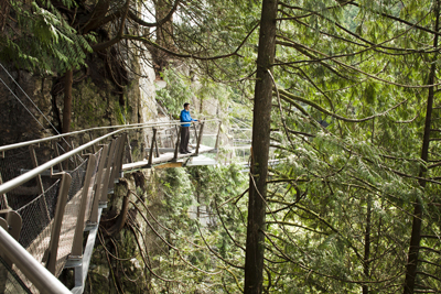
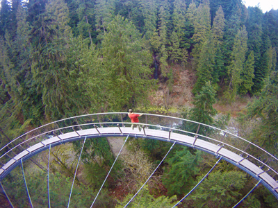
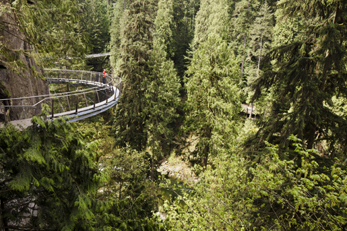
The Cliffwalk is a 213m-long, 500mm-wide steel walkway with timber decking, which is cantilevered some 3m from the face of the cliff and is believed to be the first of its kind in the world. Pedestrians can now see views that previously would only be available to experienced rock climbers, and the walkway also serves as a medium for educating them about the water/erosion cycle through a series of interactive displays.
The route allows visitors access down along the granite cliff on the east side of the park via a narrow walkway that is cantilevered from the cliff face. It includes a spiral stairway; eight bridge spans; five straight stairways; seven observation platforms, two of which have glass decks complete with a baked on ceramic anti-skid coating and glass guards; a 30m-long cable supported semi-circular bridge; stainless steel woven wire mesh guards; more than 400m of stainless steel handrail; and 510m of rock anchors.
At its highest point, the Cliffwalk is 90m above the Capilano River. Only 11m2 of foundation area is needed for the whole walkway. The idea was the brainwave of vice president of operations for the Capilano Suspension Bridge Park, John Stibbard, who was rappelling down the eastern cliff face of the canyon. He realised that the views from the cliff face would be a great attraction for visitors, but it was not feasible to enable the 750,000 annual visitors to safely access the cliff face using standard rock climbing techniques. Quite apart from the logistics involved, it would destroy the sensitive flora/fauna on the cliff face.
Many unusual difficulties had to be overcome – firstly that of how to obtain building permit approval for such a unique structure. How could the structure be built in a rainforest, with minimal impact on the environment, overcoming limited construction access, and providing a safe structure that would be slender, light and thrilling? What about the rock fall hazards or the difficulties of building without negatively impacting the visitor experience? What alignment should the Cliffwalk take and exactly where on the cliff face should the structure be located?
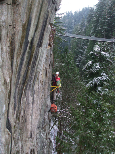
The design process began with a field reconnaissance of the rock face by rappelling to determine best foundation locations and route, all the while avoiding trees. Suitable locations for foundations were established based on visual observations of the rock face, and a total of 510m of rock anchors of three different types were used. Twelve different alignments were investigated before the route was finalised. Rock fall risk management was identified as an early design constraint.
To mitigate pedestrian exposure to any stray rock fall, most of the walkway is cantilevered by 3m. The risk of rock falls was also managed by construction of a reinforced soil slope at the crest of the cliff, stabilisation of the cliff face with rock bolts and the construction of rock fencing wherever the field testing indicated.
Survey personnel had to be trained in basic fall protection procedures as well as advanced vertical lifeline techniques. They worked their way along the cliff, mapping its face from the base. A Leica TCRA 1103 total station was selected for its superior reflectorless specifications and relatively light weight. Customised survey legs were used to aid setting up on very high angled ground. The majority of data was collected using the reflectorless capability of the total station however in some cases it was impossible to have direct sightlines to features on the cliff. In these cases, a surveyor would rappel down the cliff face with a reflector to survey particular features on the rock face.
To provide an accurate representation of the cliff, individual 3D faces were created by hand from the point data which together provided a 3D model of the entire cliff face. This required close communication and constant quality control checks between the field crews and the drafting personnel. The rock face was also inspected using high angle rope techniques and rappelling to establish an initial alignment for the walkway and also locations that required rock stabilisation.
The rock throughout the canyon is fresh, very strong, massive granite with a number of vertical faults of closely fractured rock up to a metre wide. The rock also contains sets of vertical joints that have continuous lengths of 10m to 20m and form the canyon walls.
A number of discussions were held to establish the permitting process; ultimately, conventional British Columbia building code schedules were issued by the design professionals and an independent engineer appointed to review the design and construction. The design criteria addressed the primary concern of public safety, including the construction and future maintenance activities; however the owner wanted to have a ‘lively’ structure that exhibited some excitation to live load application.
At the entrance to the walkway is spiral staircase that lands on a platform area; these stairs were deliberately wider to enable visitors to turn back at this stage if they did not feel comfortable with the height. The structure may be subject to deliberate attempts at excitation, similar to the main suspension bridge. This is managed by the presence of CCTV cameras and supervising staff.
Early on in the project it became quite evident that the design, fabrication and construction techniques were going to be heavily interconnected and interdependent. A significant amount of collaboration was needed between the structural engineer, rock engineer, erector, owner and surveyor from start to end of the project, and could not be adequately handled with a conventional procurement process.
As a result, every member was contracted directly to CSB, including all design professionals, rock drillers, material testing, electrical, steel fabricators and so on. Geometrical detailing of all the steelwork was based on the surveyed locations of the foundation base plates that were first installed in their final positions. The field coordinates of the foundation plates were then used to define the geometry using Prosteel, a 3D steel detailing program, without the ability to dry fit any pieces in the shop.
The final joint closure in the 213m-long run was only 15mm out of alignment. The design was initially based on having to erect all the structural steel without a crane, using block and tackle, rope and cables all attached to the trees at the base of the cliff.
But as construction evolved, innovative access methods were realised to get small, light high capacity all-terrain cranes on site to access a majority of the work. The support members on the