The cost of annual inspections constitutes a significant recurring expense for bridge owners and operators everywhere. In the United States alone, some estimates have placed the annual cost of bridge inspections between US$2.7 and US$3 billion. As bridges age, thorough and rigorous inspections of the aging bridge inventory can only increase in importance. The logic of the Pareto principle applies as much to bridge inspections as it does to other areas of human endeavour; 20% of the connections and details on bridge members can, on most bridges, account for 80% or more of the risk posed to the bridge structure by structural defects and deficiency. Within the limited time and shrinking budgets available for bridge inspections, inspectors cannot manually and physically inspect all parts of bridges — especially larger bridges — and still expect to do justice to all of the requirements of a bridge inspection programme.
It is in this context that the use of unmanned aerial systems or drone technology has found application in the bridge inspection arena.
Over the last decade, unmanned aerial vehicles equipped with high-definition cameras have started to find wider application in the visual inspection of bridges. At the same time, the capabilities they offer have also improved significantly. In the near future, UAVs that are compact enough to navigate through the framework of a bridge superstructure and those that can hover stably in front of bridge connections/details to allow for high-definition video and photography, will be readily available in the market.
UAVs allow the inspection team to focus on and spend more time on those 20% high-risk details and connections, while delegating the visual scanning of the lower risk areas on bridges to drones. This is not to say the areas perceived as presenting lower risk do not need to be subjected to a rigorous visual inspection. The video feeds and imagery of such low-risk areas that are obtained by drones can be recorded and reviewed in the office by engineers and inspectors; if new distress is observed, those areas can be manually inspected.
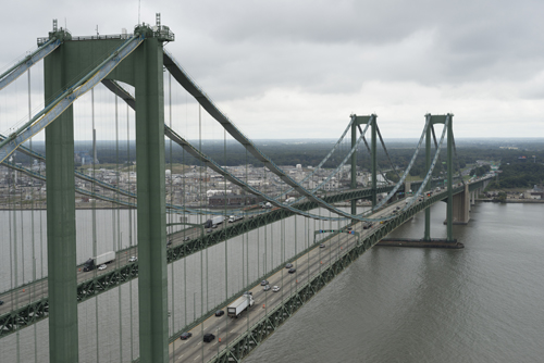
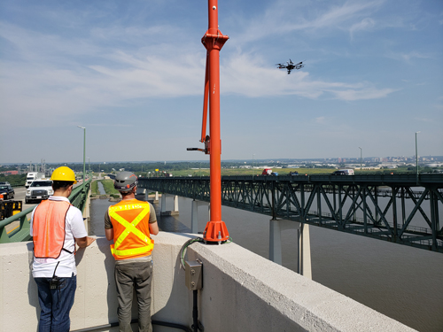
UAVs have been used for bridge inspections of the Delaware Memorial Bridges since 2015. These twin suspension bridges over the Delaware River connect the states of Delaware and New Jersey, and are subjected to a rigorous annual inspection programme. The Delaware River & Bay Authority is responsible for the operation, maintenance and upkeep of these two major crossings and in 2015 they engaged the services of WSP as a general engineering consultant. WSP was also tasked with conducting annual inspections of the two bridges, and in 2015, the firm engaged the services of UAV specialist Keystone Aerial Surveys as subconsultant-subcontractor to assist with the application of UAVs in the annual bridge inspection programme. Keystone has more than 50 years of experience in manned and unmanned flight operations for mapping, inspection, GIS and remote sensing.
One of the principal objectives of the application of UAVs and UAS technology to the DRBA’s bridge inspection programme has, from the very beginning, been that applying this technology in the inspection programme should not result in a dilution of the rigour, thoroughness, and diligence that is expected of an annual bridge inspection effort.
The preparatory effort required to initiate the drone inspection component of the programme involved obtaining the necessary clearances and permits from the FAA, informing local airports, and convincing stakeholders of the value of the proposition to deploy drones as part of the bridge inspection programme. This effort itself took about six to eight months, however the effort was well worth it since it meant that further trials and inspections could proceed with little or no regulatory hurdles.
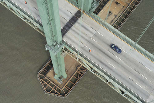
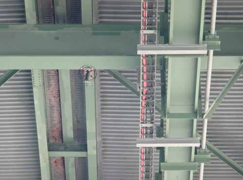
To date, UAV-enabled inspections have been performed on the suspension bridge towers, main cables, suspender ropes, the steel superstructure as well as the anchorages and piers. Some of the flights performed by UAVs have helped the engineers see nooks and corners of the bridges – whether that be on the tall vertical faces of the steel towers, or on the framing of the superstructure – that had been at best difficult to access or at worst, inaccessible without a concerted effort to erect special and expensive scaffolds to view and inspect those details.
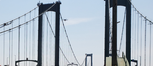
Following three successive years of using UAVs in the inspection programme, the team has attempted increasingly complex exercises, including flying caged UAVs between the tight spaces of the superstructure; viewing live feeds from drone mounted cameras on smart glasses worn by inspectors on the ground; 3D point cloud mapping of the massive bridge anchorages; and semi-autonomous and autonomous flights designed for routine safety checks on suspender ropes and bridge bearings.
The intention of these progressively more complex exercises is to gain a good understanding of the true capabilities of the UAVs being used, to closely review the quality of the deliverables – video recordings and still imagery – provided by the drones, and to develop the right tools and procedures to eventually bring this technology to a state where it is accepted as a routine, yet valuable, component of the annual bridge inspection effort.
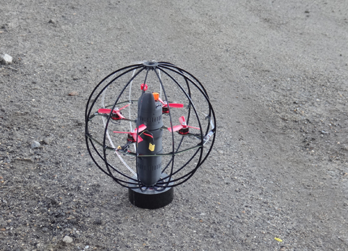
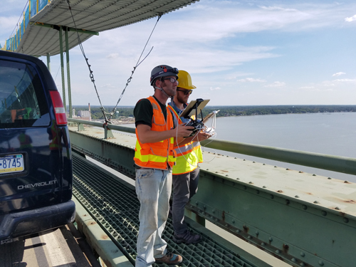
The solutions trialled for the inspections were tailored to suit the requirements of specific inspection tasks. For instance, flying a caged drone between the steel elements of the superstructure prevents damage being caused to the camera by the drone accidentally bumping into steel members. Live feeds sent by drone-mounted video cameras straight into smart glasses worn by inspectors on the ground provide the potential of safely inspecting a damaged component of a structure without the need to put inspection personnel in harm’s way.
Three-dimensional point cloud mapping helps bridge owner agencies build accurate 3D models of entire bridge structures, while semi-autonomous and autonomous UAV flights offer the promise of routine, automated drone flights to check the safety and stability of critical components of bridge structures such as suspender ropes on suspension bridges.
Stepping through these numerous trials has not been without its challenges. Caged drones used for inspections within the framing of the steel superstructure were observed to lack adequate stability to provide high-quality deliverables. The live video feeds from drone-mounted cameras, while clear and rich in detail, could only be obtained for limited time intervals due to the battery life of the small drones being eight minutes or less. The 3D point cloud mapping of massive anchorages at the ends of suspended spans contained parts that were not as detail-rich as the rest of the structure, and the semi-autonomous and autonomous flights delivered images taken from locations that, due to wind and UAV instability, varied slightly from programmed flight-path locations.
Nevertheless, in the aftermath of every trial, the inspection team has learned something new that will help with further development of this technology. For instance, the inspection team now knows that the next caged-drone flights within the superstructure framing will need a compact, yet far more powerful UAV. The variation in accuracy of the deliverables from autonomous and semi-autonomous UAV flights points to the need for better GPS connectivity or even a special, localised GPS network requirement for autonomous inspections. Great wireless connectivity between the UAV and the ground operator, combined with strong GPS signal strength, can make a vast difference in the degree of success achieved from a UAV inspection. A compact yet powerful drone – one that can hover stably even in moderately windy conditions – can significantly improve outcomes for UAV-enabled inspections.
Although some of the features that could help deliver great outcomes from UAV-enabled inspections are beginning to emerge in the market, benefits such as autonomy and change detection in site conditions can be applied right now. The cost of UAVs, cameras, and the associated devices that will help deliver such outcomes, is expected to rapidly drop over the next few years. High-quality live video feeds sent from UAVs directly to an engineer or a bridge inspector’s smart glasses, while simultaneously also being recorded for future viewing, present the one area of greatest promise in this field.
Various improvements to technology should assist in delivering better outcomes, if and when they come on stream. These include longer battery life; robust sense-and-avoid technology so that the drone can automatically avoid obstacles; advance flight planning to facilitate autonomous flight; and machine learning onboard the drone to autonomously spot possible issues.
The DRBA bridge engineering team plans to continue working with its consultants and specialists on further development of this technology, to ensure that UAVs make further inroads into bridge inspections
Shekhar Scindia is project engineer at the Delaware River & Bay Authority; David Day is executive vice president of Keystone Aerial Surveys; Matt Bacon is bridge inspection manager for WSP