Researchers predict that this new technology could save tens of millions of dollars per year in surveying costs as well as eliminating the need for potentially-hazardous inspections. It is being developed through a three-year, US$650,000 project in the UK which is being funded jointly by government agency Innovate UK, and the partners carrying out the research — Opus International Consultants and Nottingham Trent University.
Some major infrastructure authorities have already agreed to provide site access for the testing of Rustscan
The aim of the three-year programme is to develop a remote imaging system that simultaneously performs both 3D and spectral-imaging — a combination that the researchers claim is not currently available in a single system for the inspection of structures.
The resulting 3D models, along with spectral images, would provide detailed information regarding surface blistering and corrosion that could inform decisions about when to repair or decommission bridges.
“Normally a colour image has three channels, RGB, but with spectral-imaging you chop it down to more and finer channels, so instead of just three you can have ten or whatever you like, depending on the application,” explains Haida Liang, head of the imaging and sensing for archaeology, art history and conservation research group in the physics and mathematics department of Nottingham Trent University.
“We are collecting not just a 2D image but an image cube, in the sense that you have three axes, where two are spatial and a third dimension which is the wavelength.”
Crucially, the technology has already proven itself in the field of art conservation where it has been used to closely examine wall and ceiling paintings that would have been inaccessible without external support.
Prisms — which stands for Portable Remote Imaging System for Multi-spectral Scanning — was originally developed with a grant from the Engineering & Physical Sciences Research Council. This three-year project, which started in 2007, resulted in a spectral-imaging system that allows automatic, in situ, high resolution, remote imaging of paintings at distances of up to 35m. It provides not only spectral information per pixel of the paintings but also 3D position and distance measurements.
The technology has been deployed since 2011 on the Unesco world heritage site of the Mogao Caves near Dunhuang at the edge of the Gobi desert in China. This Buddhist temple site, whose history extends from the 4th to the 15th century, consists of 735 caves and 45,000m2 of wall paintings.

Mogao Caves, Gansu, China; colour image derived from spectral images taken at 11-12m and automatically mosaicked together
In the Mogao caves the spectral imaging was successful in revealing Sanskrit writings and drawings invisible in any other colour images. It also provided a working imaging resolution of 80µ at a distance of 10m. Liang’s research group has since collaborated with experts from the Tate Gallery, the British Museum and English Heritage, among others.
The potential applications of 3D spectral imaging in civil engineering came to light in November last year when James Hulme of Opus International Consultants approached Nottingham Trent University for assistance with a number of remote imaging issues: “Our research grant capture team realised that I was doing something relevant for remote imaging so they called me along,” recalls Liang: “When I heard James’ problem with rust I thought — it is the same as red ochre.” Red ochre is a natural earth pigment that is used to make paint and is made up of the same chemical ingredient as rust: iron oxide. “And at that point we clicked.”
The research grant enables the partners to be more ambitious in the transfer of the technology from the field of conservation to structural inspection. The team has set its sights on extending the surveying distance from 30m to 100m: “We are creating a next-generation system that won’t be like the original. We can go back to the drawing board and do something totally different and smarter,” says Liang.
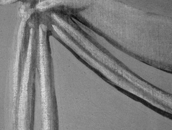
Kedleston Hall, Derbyshire, England; marble hall painting imaged from a distance of 23m at a wavelength of 600nm
The aim of the project is to develop Rustscan, a hand-held, tripod or UAV-mounted instrument that will collect and generate detailed data regarding surface blistering and corrosion via specially-developed software called Rustdetect.
As well as showing surface rust and corrosion, the software will be able to provide a time-specific record of the condition of the bridge for comparison with future scans. The capability for comparing images in order to ascertain deterioration in a bridge is not regarded by Liang as particularly challenging: “It is a relatively simple process that people are doing, but you need to be careful with calibration.”
The project has been divided into two parts. The first is to develop the hardware and the software that drives it; and the second part is to find a way to handle the sheer volume of data that is generated: “Big data is a problem. We have to find a smarter way of dealing with — and processing — all these high-resolution data image cubes,” explains Liang.
Once these hurdles have been overcome, Hulme is confident that the technology will be used in practice to inspect bridges and other structures: “We’ve outlined three types of application: a 100m overview of a structure; a hand-held view; and a close-up perspective. The latter application will be transferable to UAVs and that will be important because you can’t see everything from the ground at a distance.”
As already mentioned, the existing system has a resolution of 80µ at a distance of 10m but Hulme doesn’t see this level of accuracy as being the standard setting in the commercial solution. Rustscan would instead offer a variety of settings depending on whether a rapid or detailed overview was required. “Normally these things are based on volume of data versus time to collect it, versus cost. You have a trade off,” says Hulme. “The sensible thing is not to have full resolution for the entire structure but instead to have a low resolution which you then change to high in order to concentrate on the bits where there are problems. But those kinds of details will be dealt with through the course of the project.”
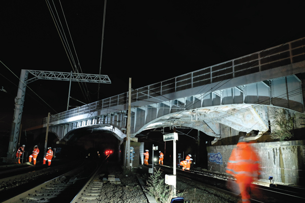
Hulme is confident that the technology will be useful for Opus as the company carries out thousands of bridge inspections every year for the railway industry: “Part of our work involves people crawling around and touching the structures, and that is a really important part, but equally important is to take images and collect 3D laser scanning data. Wouldn’t it be great if we could spend the same amount of time on site but come back with a much richer data set? Take the huge steel arch structure of St Pancras Station in London, for example. Where do you start your inspection? It would be very useful if, prior to beginning the principal five-yearly inspection with all the scaffolding that’s required, we could use a rapid assessment technique to identify the hot spots.”
Currently the majority of the development is taking place in the lab, where Liang and her team are currently rusting and coating objects and then analysing the imaging data. A significant challenge to achieving the 100m operational distance is quantifying the levels of light that would be required for daytime and nighttime surveys, and the group will be researching this area in the coming months. This work will eventually be followed by full-scale applications and, says Hulme, some major infrastructure owners have already agreed to provide access for field testing.
Rustscan and Rustdetect will hit the shelves commercially in stages and, understandably, Opus will have the opportunity to deploy them first. Nevertheless, those interested in seeing the technology in action may have the opportunity to do so sooner rather than later, says Hulme: “We are hoping to be working with it in the real world in just a few months’ time”.